
Services
01
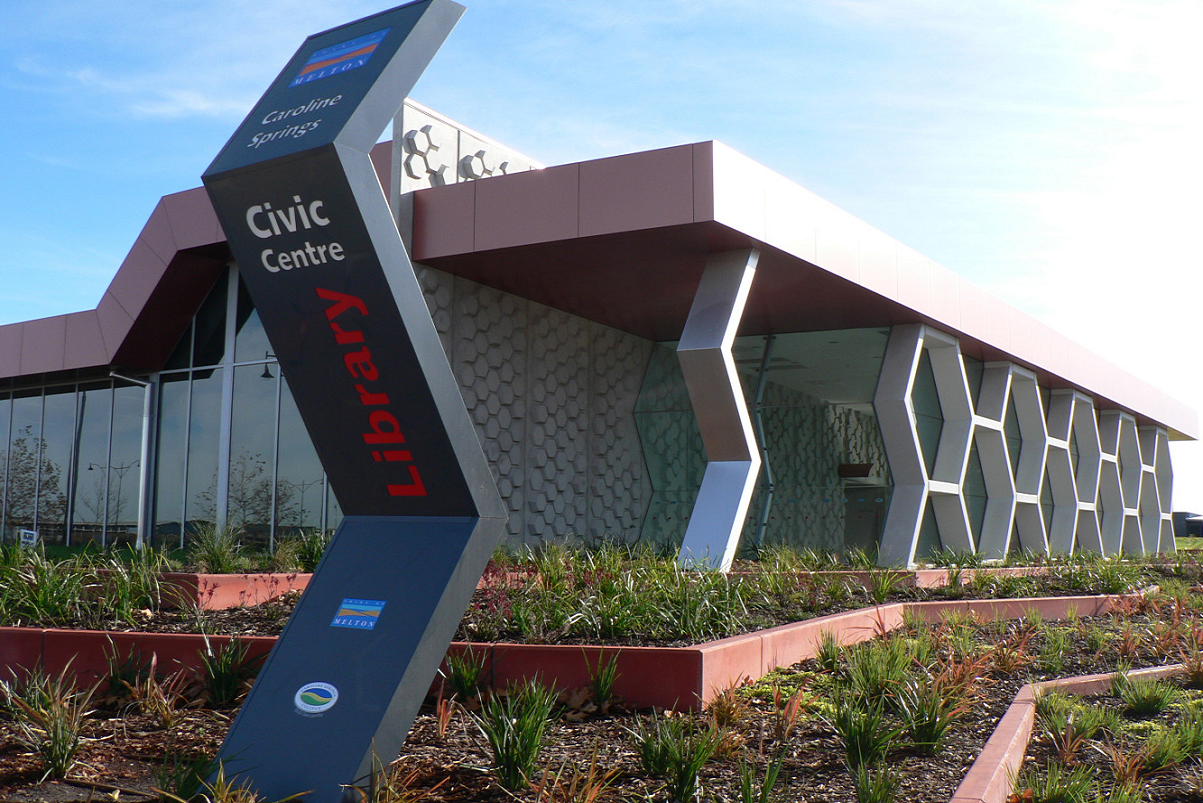
Way Finding
Research and Analysis
Traffic Pattern & Circulation
Circulation Systems
Wayfinding
Cognitive recognition
Spatial Orientation
Evaluation and development

Where and when is a wayfinding analysis necessary
Wayfinding analysis is very important in today’s society. We at Way Forward contend that we are not in the sign business rather that we are in business of solving problems for our customers.
A wayfinding analysis requires resources, both time and personnel, therefore the projects must have a certain size and/or complexity before a wayfinding analysis should be considered.
The wayfinding analysis is the first link and should be completed before commencing with details such as sign design, method of sign construction and so forth.
Definitions
Among experts a certain terminology is used in wayfinding.
The following paragraphs deal with some terms, which it would be practical to define.
Circulation or Traffic (Flow, pattern)
The terms circulation and traffic flow describes the movements of the user in a certain area. The users want to reach certain destinations. Even when sightseeing the users have a certain goal in terms of where they want to go to and may want to return to the point of departure. To reach an unknown destination, even to follow a well-known route, is a complex interactive process.
The circulation or traffic pattern is the number of routes which the user can use in a given area.
Circulation systems
When circulation is the sum of routes in a given area, the circulation system is the system or structure formed by these routes or the lack of same.
Wayfinding
The concept of wayfinding is defined as the methods, according to which the users reach given destinations.
Wayfinding is a spatial problem-solving process, including many elements: memory and learning, spatial conception, traditional and cultural backgrounds, fantasy, impression and systematics.
Cognitive map
The internal cognitive map is defined as the ability of a person to imagine a map of an area and to place himself in it. It is a part of the subjective and simplified perception of the physical and nonphysical picture of the environment.
Spatial orientation
Spatial orientation is defined as the way a person perceives his location in his surroundings. It is a measure of the mental ability to imagine where you are located in your surroundings. Spatial orientation is connected with the cognitive mapping.
If you imagine the cognitive map of Australia, most Australians know where they are if they are, for instance in Victoria. Then they know that they can travel a long distance without having to travel by ship. They know their location in comparison to their surroundings, even without a map. They have spatial orientation by means of their internal cognitive map.
Area
Area is defined as the territory, the space, the area, the building complex or the precinct which is to be reviewed. The same principles and methods apply to interior as well as to exterior environments.
Destination
The final physical destination of the user. This can be compared to the destination in a journey by train or aircraft.
User
Users are persons who find their way through the use of the wayfinding system. Users who are members of the staff and who – after a short period of time are familiar with the surroundings – are no longer considered as users.
Customer
The customer is defined as the person who is responsible for the function of the wayfinding system in the area.
Locality
The description of a physically limited part of the area. One or more localities can be destinations for the single user.
Destination zones
Indicate a group of destinations which together build a locality with common characteristics.
For example, a big division, more divisions with similar functions, a building within a complex of buildings, a floor etc.
Plan-layout
Drawing showing the area as seen from above with the roof and/or floors taken off.
Other designations: ground plan, floor plan, blueprints, horizontal plan.
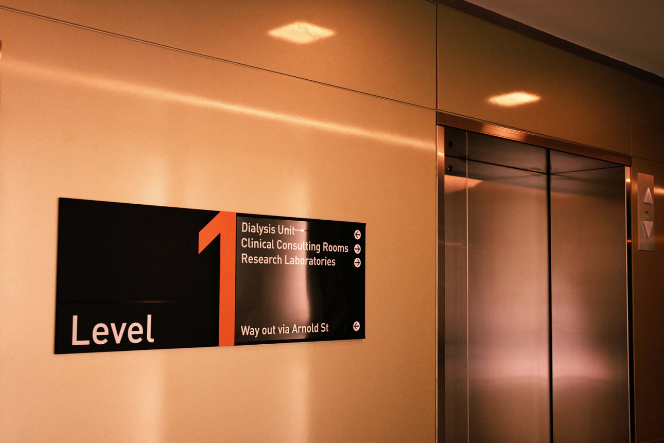
Wayfinding system
General designation of the system which makes wayfinding possible. Also known as a Signplan.
Here we think of overall solutions which may comprise not only signs but also all other means of wayfinding.
These are the elements that we utilise to construct a Wayfinding Solution

02
Sign Planning
Reviews and analysis from Wayfinding Solution
Strategic Planning of signs
Review for DDA requirements
Full Documentation of database of signage
Development of graphic design element for signage
Development of sign type function
Sign type, design and construction for specific needs
Client reviews and editing of sign plan
Cost Estimation
Planning approvals and submissions
Project Management
Tender evaluation and implementation reviews
Research and Analysis
Based on the Wayfinding solution a signage plan can be formulated by gathering the information from the research and the architectural footprint of the project. This is the basis of the commencement of the signplan
Strategic Planning
The signplan is generally created with strategic positioning of signs throughout a project.
Review for DDA
As there is mandatory and highly recommend signage required for facilities we use best practice for the placement and design of the signage.
Full Documentation
The signplan is created in a user friendly database that can be accessed by each client for review.
This documentation can then be formalised for issue signage contractors. This could be in the form of tender documents or for D&C contract.
Graphic Design
The design process is where we create the “look” of signage either to suit the corporate identity or a stylised format to suit the environment. This can be done as simple colour illustrations, 3D illustrations or photographic illustrations. This also includes for logos, artwork and typography.
Sign Type
Each sign needs to be specific for its needs. So we prepare a suite of sign types to create a family of signs designed to be uniform but specific for its needs. The sign type design and construction method is done at this point.
Reviews
With any database or design document continual reviews are required prior to the final document being released.
Cost Estimation
With our previous manufacturing background we are able to provide precise estimates for any project works. This assists with many new development projects in early stages of planning or development.
Planning Approvals
All documentation can be provided and issued to the relevant planning authorities for approval.
Project Management
Where requested we can undertake the project management of any implementation project from tender to final defects inspection.
Tender Evaluation
Where requested we can provided the service of review and evaluation of tender submissions and also review samples for approval.
These are the services that we can provide for any successful implementation program.
Get in touch
We have over 30 years experience in Wayfinding and Signage Planning.